seaside

Mechowskie Caves
Discovered in 1818 the greatest curiosities of inanimate nature in...

Orłowo Pier
The first small pier for ships in Orłowo, then known as Adlershorst...

Orłowo Cliff - The Power of Erosion and the Beauty of the Natural Coastline
The Orłowo Cliff is one of the most recognizable landmarks in...


Observation Tower in Gniewino - Kaszubskie Eye
Turistic-Recreational Complex "Kaszubskie Oko" is a facility...

Pałac Przebendowskich - Museum of Kashubian-Pomeranian Literature and Music
One of the attractions of Wejherowo is the Przebendowski and...

Lookout on the Bay of Gdansk and Hel Peninsula
Lookout near the train skm in Rumia. From here you can admire the...

Fountain of Neptune
It was founded in the seventeenth century by the councilors of...

Łaźnia Contemporary Art Center in Gdańsk
The gallery is located in the historic building of the former...

nEnglish:nnThe Slovincian Village Museum in Kluki: A Journey Through Culture and Heritage of Pomerania
In Kluki, beautifully situated by Lake Łebsko in the Słowiński...

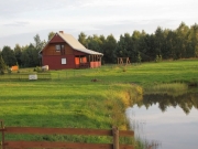
Historic 18th-Century Manor House Accommodation Near Lake: Events and Relaxation
A historic 18th-century manor house located in charming surroundings,...

Agritourism near Puck Bay: Kayaking and Active Recreation surrounded by Attractions
The farm is located 15 kilometers from the Bay of Puck with good...

Recreation Center near Gdańsk | 7 km to Center, Horse Riding, Lake, 2,3,4 Person Rooms
The facility is located 7 km from the center of Gdańsk, in a forest,...
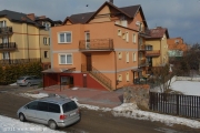
Accommodation in Sopot villa: close to beach and transport links, ideal for business and leisure
We would like to invite all of you to the Villa in Sopot. The house is...
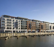
Luxury Apartments Gdańsk Motława | Crane View, Close to Długa Street and Marina
Exclusive apartments are located in a modern complex on the Motława...
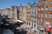
2-Room Apartment Gdańsk Center | 5 Minutes to Old Town, View of Monuments and Washing Machine
The apartment is located in the heart of Gdańsk overlooking the old...
Camping in a Pine Forest 150m from the Cleanest Beach in Tricity
The Camping - open from April 25 to October 5 - is located in a pine...

Holiday Resort and Camping 300m from Puck Bay - Cottages, Rooms, Sport and Recreation
The facility is located in the buffer zone of the Seaside Landscape...

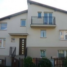
Comfortable Holiday Cottages and Rooms with Kitchens in Władysławowo - 1.5 km to the Beach, Near the Bike Path
2-bedroom holiday cottages with a terrace: Living room, bedroom,...

Lodging in an atmospheric house by the Hel Lighthouse – Rooms and Apartment with kitchen
Welcome to this authentic house, which since the nineteenth century...
Wooden Holiday Cottages with kitchenette and TV – Jastarnia, by the Marina
We invite you to spend your free time in Jastarnia. We have wooden...
Comfortable, two-bedroom holiday cottages with kitchen, terrace, and barbecue – Jastarnia
The plot is fenced with a locked gate, which will maintain proper...

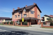
Hotel and Fine Restaurant: Ideal Venue for Special Occasions and Festival Stay
A manor house offering accommodation, located closest to a large music...
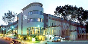
Luxury Hotel **** Gdynia by the Bay: Close to Beach, Boulevard, Conferences, Pet-Friendly
The luxury facility **** in Gdynia is located on the very coast (by...

SPA Hotel **** near Gdynia: Pool, Wellness, Conferences, Good Access to Tri-City and Hel
The 4-star SPA Hotel is situated 8 km from the center of Gdynia, 25 km...
Intimate Rooms with Private Bathrooms and Wi-Fi | Gdynia Private Parking | Welcoming Atmosphere
In our humble abode reigns hospitality, discretion, and the principle...
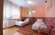
Guest Rooms with Various Standards and Kitchen Access - 20 Minute Walk to the Beach
We have guest rooms with private bathrooms. We have a fully equipped...
Large two-room apartments with kitchen and Puck Bay view – Władysławowo
Enjoy your holidays by the sea in Władysławowo. We have two...

Accommodation Sopot Center: 300m to sea, rooms/apartments with parking, ideal for training
It is located in the center of Sopot, 300 meters away from the sea. We...
High Standard Accommodation Gdańsk Brzeźno | 50m from Beach, Near Pier and Stadium
We invite you to the Facility where you will be surprised by a very...
Facility with Convenient Tri-City Location | Near Bypass, Entertainment and Gdańsk Old Town
The facility is located 2 km from the Karczemki Junction of the...

Year-Round Holiday Resort Near Pine Forest and 15 Minutes to the Beach
We would like to invite you to enjoy the year-round Recreation and...

Modern Resort with Pool, Sauna, Restaurant, close to the beach – Władysławowo
We warmly welcome and invite you to read the offer of our Holiday...
Lodging in the Center with apartment, large kitchen, parking, playground, 200m to the bay – Jurata
Welcome to the holiday home, which is located in the city center, in a...
Accommodation in Sopot near Hippodrome: good communication, proximity to beach and sports activities
The facility offers rooms with private facilities. It is very well...
Comfortable and Cozy Relaxation in Władysławowo - Perfect for a Successful Seaside Holiday
We invite you to relax on holiday in Władysławowo. We provide...

Rooms with a view of Puck Bay | Accommodation right on the bay | Free parking, barbecue, balconies
The house is situated right on the Bay of Puck, balconies are in every...

Accommodation for tourists and remote work in the countryside: Rooms with Wi-Fi and a peaceful atmosphere
We invite tourists and people working remotely who want to move their...

Sopot Center Hostel: with a garden, relaxed atmosphere, close to Monciak and beach, for travelers
We invite you to a cozy hostel in Sopot. The city needs no...
Restored Historic Building Gdynia | Elegant Accommodation with Restaurant and Proximity to Nature
The facility is ideally located in Gdynia at the national road No. 6...

Hotel and Manor with Guarded Parking and Restaurant - Close to Tricity and Kashubia
Polish hospitality is a feature so well known that it has entered the...