search
3
2
2
/
kashubia
/
attractions
The Devil's Stone by Lake Kamienne – The Mystery and Beauty of Kashubia
In the northern part of the Mirachowo Forests, on the shore of Lake Kamienne, lies one of the largest glacial erratic boulders in Pomerania – the...
description
map
qrcode
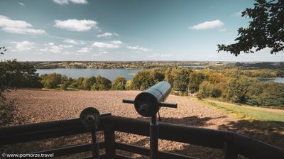
Tamowa Hill – A Viewpoint in the Heart of Kashubia
Tamowa Hill (224.1 m above sea level), located in the Szymbarskie Hills range, is a unique viewpoint near Chmielno, offering expansive panoramas of...
description
map
qrcode
Wdzydze Ethnographic Park: History and Traditions of the Kashubians
The Museum - Kashubian Ethnographic Park named after Teodora and Izydor Gulgowscy in Wdzydze Kiszewskie, whose origins date back to 1906. The founders...
description
map
qrcode
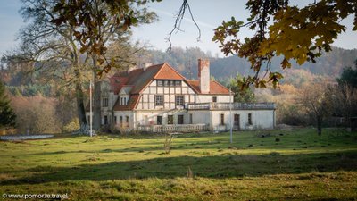
Manor House in Paraszyno - History, Architecture and Picturesque Landscape
The Manor House in Paraszyno, built in the second half of the 18th century, belongs to the group of manors of the Pomeranian nobility and is an...
description
map
qrcode
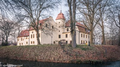
Krokowa Castle - History and Heritage of the von Krockow Family
Krokowa Castle, dating back to the 14th century, is a beautiful architectural gem in the heart of Kashubia. Initially a defensive knightly residence,...
description
map
qrcode
Żarnowieckie lake - ideal for sportsmen, anglers, naturalists.
Lake Żarowieckie (Kashubian Lake Pioszniccze) jezt glacial lake gutter, surrounded by a 100 meter long moraine hills, which on the west bank are...
description
map
qrcode
Power plant in Żarnowiec
In the 80 on the eastern shore of the lake was built the first nuclear power plant in Poland. As a result of social and political changes in the turn...
description
map
qrcode
Archeological site - Seal hunters settlement
Along the shores of Puck Bay, there are remnants of a seal hunters' settlement. Archaeologists discovered its traces in the late 19th century, but...
description
map
qrcode
The platform for navigation in Rzucewo - view of the Puck Bay
Mooring jetty with pediment. Permanent reinforced concrete bridge with a length of 26 m. The wooden bridge deck. Floating bridge with a length of 36...
description
map
qrcode
Lime avenue Sobieski
Apparently, King John Sobieski himself planted some trees when the village was owned by his sister Catherine. Worth to see the castle and this avenue...
description
map
qrcode
Boulders of the Twelve Apostles
Inanimate nature monument on the shores of the Bay of Puck. Monument is a group of storm surges rinsed by boulders. The largest with a circumference...
description
map
qrcode
The tomb of the von Below family
The tomb of a powerful, extensively branched, landowning-junker family with a rich history. This family owned many estates, including in Pomerania....
description
map
qrcode
Stefan Żeromski Lighthouse in Rozewie
In the 17th century, a Swedish ship wrecked near Rozewie. The entire crew, including the captain, perished, except for the captain's daughter, who was...
description
map
qrcode
Closed lighthouse in Rozewie
The increase in maritime traffic in the second half of the 19th century resulted in frequent navigational errors by ships passing Rozewie at night on...
description
map
qrcode
City Hall in Wejherowo
The Town Hall is located on the market square (Jakub Wejher Square) and is the architectural hallmark of Wejherowo. The first town hall was built in...
description
map
qrcode
Instagram
Youtube
Facebook
1
2
3
4
5
•••
22